Denver has endless options for hiking, but if you want a quick, heart-thumping workout with a definitive start and finish, find it at one of the many sets of stairs around town.
Red Rocks is the go-to for most people, but it’s not your only option. There are several other outdoor inclines and staircases within an hour of downtown Denver, plus a few indoor spots for when the weather doesn’t cooperate. Some are quick 15-minute leg burners. Others will ruin you for the rest of the day (looking at you, Manitou).
Here’s a quick look at every spot on this list, followed by detailed write-ups with parking, hours, and tips for each.
| Location | Steps | Difficulty | Drive from Denver |
| Red Rocks Amphitheater | 315 | Easy to Hard | 15 mins |
| Mother Cabrini Shrine | 373 | Easy/Moderate | 25 mins |
| Rueter-Hess Incline | 132 | Easy | 30 mins |
| Challenge Hill (Philip S. Miller Park) | 200 | Moderate | 35 mins |
| Manitou Incline | ~2,768 | Extreme(ly Had) | 80 mins |
| Broadmoor Seven Falls | 224 | Moderate | 70 mins |
| Colorado State Capitol (indoor) | 99 (dome climb) | Easy | Downtown Denver |
| Coors Field Stair Climb (annual event) | 1,998 | Moderate/Hard | Downtown Denver |
Outdoor Stairs and Inclines
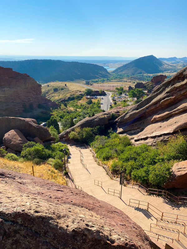
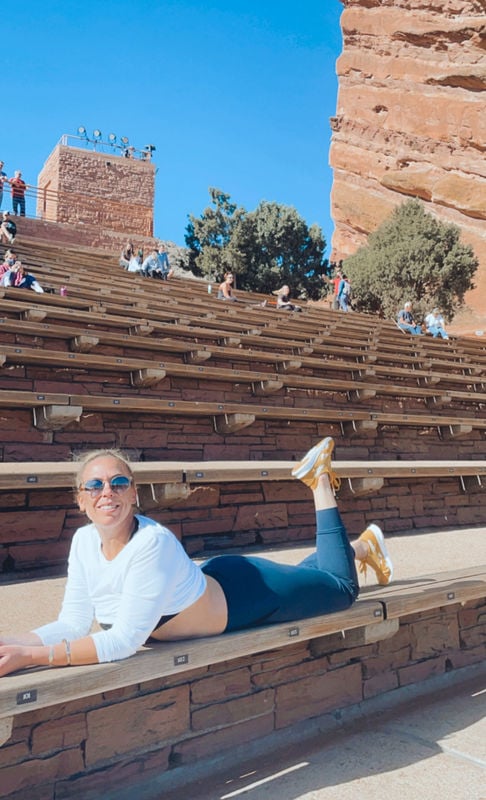
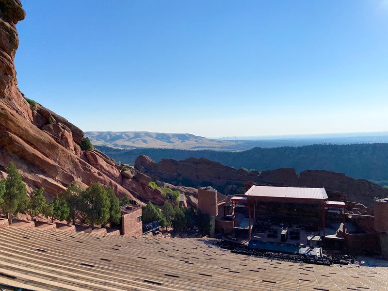
Red Rocks Amphitheater
I have to start with the holy grail of music venues that doubles as an epicenter of outdoor workouts for locals and visitors alike. Always loaded with people working on their fitness, Red Rocks is a haven for active outdoor folks looking for a see-and-be-seen spot to get their sweat on. You get everything from older ladies with ankle weights to sand-bag-squatting muscle heads. The people watching doesn’t get better than Red Rocks on a mid-morning weekend.
A lot of runners trek across all 69 rows of the amphitheater, back and forth, making their way from the stage to the top, which totals 2.7 miles. There are also miles of hiking trails throughout Red Rocks Park, connecting to nearby Matthews/Winter Park and Dinosaur Ridge.
If you’re coming for the stairs, here’s what you need to know:
- Location: Morrison, CO (15 minutes southwest of downtown Denver)
- Level: Easy-difficult (choose your own adventure)
- Total steps: 315
- Steps from the stage to the top of the plaza: 145
- Steps from the east parking lot on Trading Post Road to the stage: 194
- Elevation gain: 145 feet (from the stage to top of the plaza)
- Parking: Park at the bottom on Trading Post Road and work your way up. Otherwise, drive up to one of the several parking lots that connect to the amphitheater with their own sets of stairs. There’s also two large lots at the top of the plaza. If you’re just here to take in the vistas, park there and it’s a short walk to the amphitheater.
- Hours: Check the website for hours, as they do close the amphitheater and surrounding stairs for events. On non-event days, the amphitheater opens one hour before sunrise and closes one hour after sunset. On event days, it opens one hour before sunrise and typically closes at 2pm. Hours for car entry also change throughout the year, though cars are typically allowed to enter the park until 7:30pm.
- Fee: Free entry and free parking on non-event days.

Mother Cabrini Shrine
Not far from Red Rocks, the 22′ Sacred Heart of Jesus statue can be seen driving west on I-70. A “stairway to prayer” leads you up to the landmark, built in 1954, while giving you a nice little workout along the way. There is also a chapel, meditation walk, rosary garden, and overlook with views stretching across the Front Range.
- Location: Golden, CO (25 minutes west of downtown Denver)
- Level: Easy/moderate
- Steps: 373
- Hours: Open 7:00am-4:30pm, 7 days a week, weather permitting
- Fee: Free
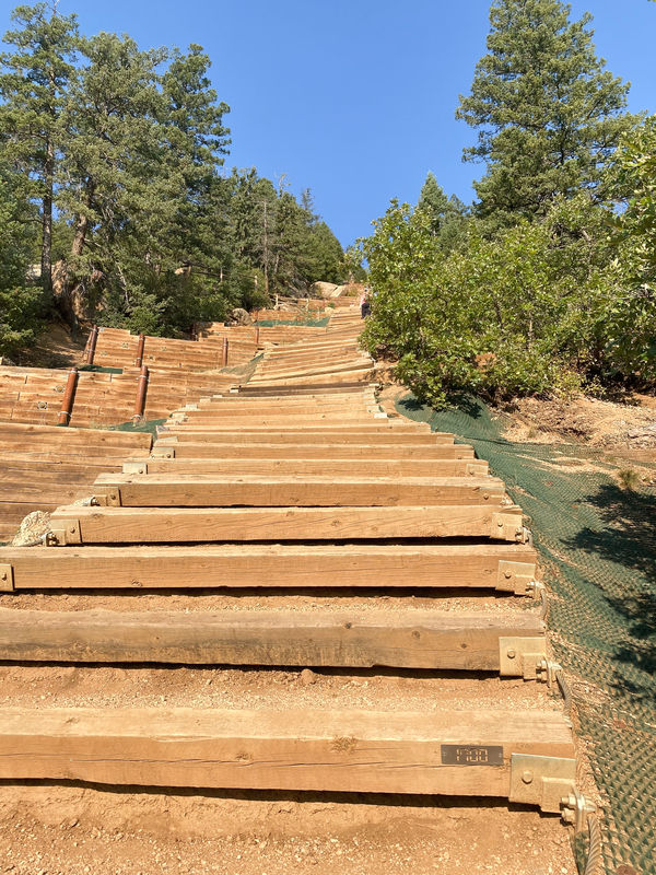
Rueter-Hess Incline Challenge
One of the newer inclines in the Denver metro area, this one opened in late 2020. The freshly installed wooden steps offer a consistent incline at 10″ x 10″ and 6′ long, which makes for a more uniform climb than the uneven railroad ties at Manitou.
- Location: Parker, CO (30 minutes south of downtown Denver)
- Level: Easy
- Steps: 132
- Elevation gain: 232 feet
- Getting down: Return down the stairs or, especially if it’s crowded, opt for the gravel trail running along the east side of the hill that leads back to the parking lot.
- Full loop distance: Just over a mile
- Parking: Follow the road west, past the Rueter-Hess Water Purification Facility, to a designated parking lot with 28 spots
- Hours: Sunrise to sunset 7 days a week
- Fee: Free
The Challenge Hill at Philip S. Miller Park
Affectionately known as the “mini Manitou Incline,” The Challenge Hill is part of a larger park and sports complex. There’s a playground, miles of hiking trails, picnic areas, and a zipline course. Relax at the top of the incline (there’s a bench to catch your breath) with views of Longs Peak and Devil’s Head.
- Location: Castle Rock, CO (35 minutes south of downtown Denver)
- Level: Moderate
- Steps: 200
- Elevation gain: 178 feet over 0.1 miles
- Getting down: These stairs can get crowded, so opt for the short, 0.5-mile trail back to the base with views of Pikes Peak in the distance
- Full loop distance: 0.6 miles (with additional connected trails to make a longer hike)
- Hours: Sunrise to sunset 7 days a week
- Fee: Free
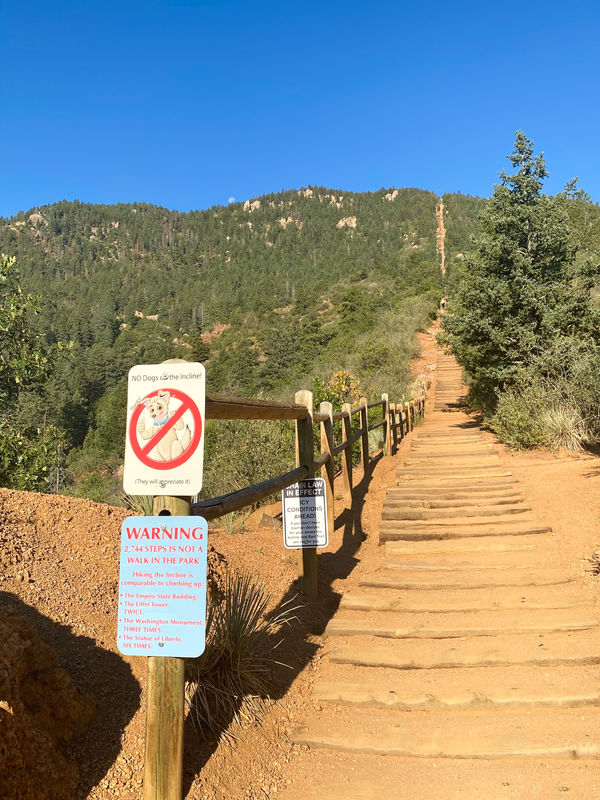
Manitou Incline
This one’s farther away, but it is THE INCLINE OF ALL INCLINES. Originally a cable car track, it now attracts tourists from all over the country and is a regular workout for the most hardcore stair climbers in the Denver metro area. Even Olympic athletes train here.
The record is held by Joseph Gray, who finished in 17:45. Allie McLaughlin holds the female record at 20:07. I love doing stairs, though I’m not fast by any means, and it took me 65 minutes to summit after taking lots of breaks along the way to catch my breath.
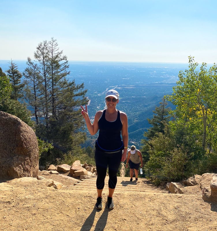
Views from the top are incredible, stretching over Colorado Springs and the eastern plains. It is one of the best inclines in the country and will get that heart rate soaring.
Important: reservations may be required. The City of Colorado Springs requires a free online reservation 7 days a week. Summer hours (May 1 through October 31) are 6:00am to 6:00pm. Winter hours (November 1 through April 30) are 6:00am to 3:00pm. Reservations open on the 1st of each month for the following month. Book at ColoradoSprings.gov/Incline.
- Location: Colorado Springs, CO (1 hour, 20 minutes south of Denver)
- Level: Difficult
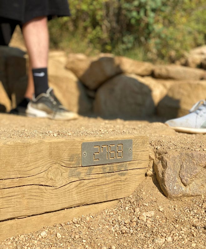
- Steps: ~2,768 (marked with gold plates throughout the climb)
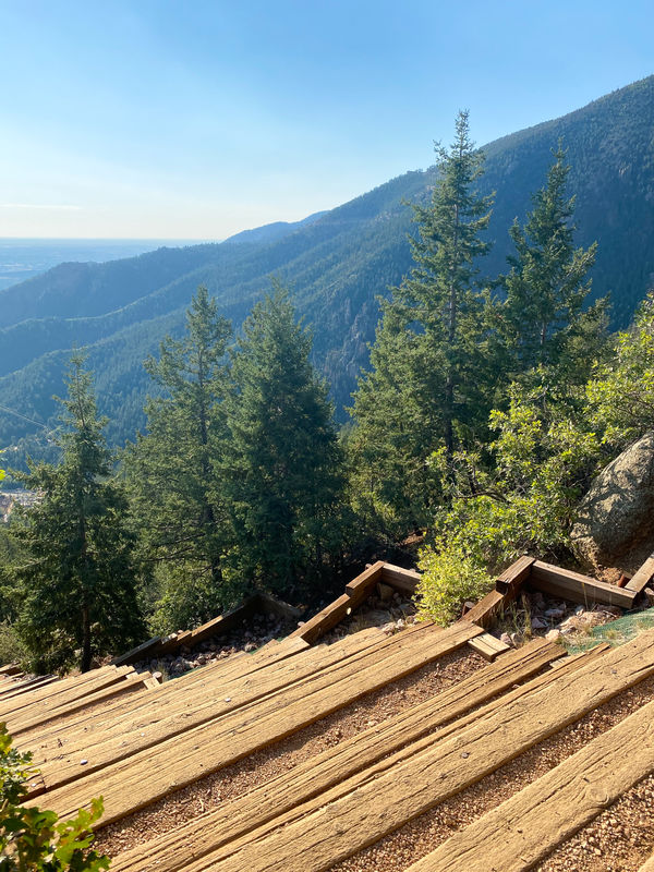
- Elevation gain: 2,000 feet over ~0.9 miles. It is steep! The average grade is 45%, getting as steep at 68% in some parts.
- Time: Plan for 3+ hours. The climb itself can take 60-90 minutes, plus the hike down.
- Getting down: Hike the ~4 miles down Barr Trail. They highly discourage hiking down the stairs for everyone’s safety.
- Full loop distance: 5 miles
- Bailout points: At railroad tie #395, a short connector leads to Ute Pass Trail and back to the trailhead (~0.35 miles). At #1,300 (roughly the halfway point), another connector leads to Ute Pass Trail for about 1.5 miles back to the base.
- Reservations: Reservations are required. They are free, allowing up to 45 reservations per 30-minute time slot.
- Parking: Do not park on Ruxton Avenue or Winter Street (residential permits only, you will get a ticket). Park at Hiawatha Gardens (10 Old Man’s Trail, paid parking) or Iron Springs Chateau (444 Ruxton Avenue, paid parking with reservations). A free shuttle runs from Hiawatha to the trailhead every 10 to 20 minutes depending on the day. Allow 30 to 45 minutes for parking, shuttle, and walking to the base before your reserved time.
- Reservation: Free, required. Book at ColoradoSprings.gov/Incline. No pets allowed.
- Fee: Free (parking is paid)
- Tips: Bring lots of water and sunscreen. Start early to avoid afternoon thunderstorms (they build after 2pm in summer). If you haven’t hiked at altitude before, this is not the place to start. There’s no shame in turning around.
Broadmoor Seven Falls
While we’re talking about Colorado Springs, it’s worth mentioning this epic spot. The Broadmoor Seven Falls incline follows a—you guessed it—seven-tiered cascading waterfall. Almost as notable as the hike itself is the drive up to the trailhead, which is one of the most beautiful spots in all of Colorado.
- Location: Colorado Springs, CO (70 minutes minutes from downtown Denver)
- Level: Moderate
- Steps: 224
- Elevation gain: ~178 feet over 0.1 miles
- Getting down: Two trails will lead you back down to the trailhead, or you can take the stairs for the most direct route.
- Full loop distance: 0.6 miles
- Fee: Admission fee applies (check the Broadmoor website for current pricing)
Indoor stair workouts (for when the weather doesn’t cooperate)
Colorado winters, spring snowstorms, and summer lightning can all shut down outdoor stair workouts. Here are a couple of indoor alternatives in Denver proper.
Colorado State Capitol Dome Climb
This isn’t a workout in the traditional sense, but it’s a fun one to know about. The Capitol offers free guided tours Monday through Friday that include a climb to the dome observation area. It’s a 99-step staircase above the 3rd floor (no elevator access) that leads to a 360-degree outdoor observation deck with views of the Rockies and downtown Denver.
While you’re there, find the “One Mile Above Sea Level” inscription on the west entrance’s 15th step. (Fun fact: it’s not actually exactly one mile. More recent surveys put the true marker at the 13th step.)
- Location: 200 East Colfax Avenue, Denver (downtown)
- Steps: 99 (dome climb)
- Hours: Capitol is open Monday through Friday, 7:30am to 5:00pm. Free guided tours on the hour from 10:00am to 3:00pm, first come, first served, limited to 30 people. Self-guided dome tours are not permitted.
- Fee: Free
Coors Field: Fight For Air Climb (annual event)
If you want a true indoor stair climbing challenge, the American Lung Association hosts the Fight For Air Climb at Coors Field each spring. Participants climb 1,998 stairs in support of those with lung disease. It’s a fundraiser, not a gym session, but it’s a great event and a solid way to test your stair fitness against a clock.
The event typically takes place in April. Check the American Lung Association Colorado page for registration and dates.
- Location: Coors Field, 2001 Blake Street, Denver (downtown)
- Steps: 1,998
- Level: Moderate to hard (depending on your pace)
- Fee: Registration required with fundraising minimum